The striking karst hills of Gunungkidul in Yogyakarta, Indonesia, stand today as a towering monument to deep-time geology, marking an ancient seabed thrust upward millions of years ago through profound tectonic and geomorphological shifts. Long before modern infrastructure connected the southern coast to the bustling centers of Java, naturalists were drawn to this formidable limestone topography. In 1836, the German naturalist and explorer Friedrich Franz Wilhelm Junghuhn documented the rugged terrain and traditional Javanese life in his seminal work, Licht- und Schattenbilder aus dem Innern von Java. Junghuhn expressed profound admiration for the natural splendor of the region, noting how local populations ingeniously navigated the intricate karst valleys and subterranean cave systems—historically venturing into the abyss to harvest edible swiftlet nests.
During his expeditions, Junghuhn permanently captured the essence of the area, then historically referred to as Goenoeng Sewoe (the Thousand Mountains), in his painting titled "Zuidkunst Beoosten Rankop." His work immortalized the panoramic vistas of the sweeping southern ocean viewed from jagged limestone precipices near Rongkop’s Ngungap Beach. Today, modern explorers retracing these routes encounter a virtually identical geological framework. Contemporary coastal sites across Gunungkidul—including Kesirat, Watunene, Siung, Pengilon, and the sequestered pocket of Wohkudu Beach—exhibit the same sharp, marine-carved coral limestone formations that have defined the southern coastline for millennia.
The Anatomy of a Karst Coastline: Geological Context
The Gunungkidul karst region is a globally recognized geological laboratory, classified primarily as a tropical tower karst system. Formed during the Miocene epoch—roughly 20 to 15 million years ago—the region was originally a vast carbonate platform submerged beneath a shallow sea. Tectonic uplift associated with the Indo-Australian Plate subducting beneath the Eurasian Plate gradually forced these marine deposits above sea level.
Over subsequent millennia, chemical weathering, rainwater dissolution (karstification), and wave action carved out the dramatic cliffs, subterranean rivers, and concealed pocket beaches that characterize the southern edge of Java. Wohkudu Beach serves as a prime micro-example of this ongoing geomorphological evolution. Flanked by twin karst promontories that act as natural breakwaters against the notoriously violent waves of the Indian Ocean, the beach features a narrow white-sand cove that encapsulates the raw power of marine abrasion. Unlike the wider, heavily developed strands found elsewhere in the Special Region of Yogyakarta, Wohkudu remains a pristine, isolated inlet enclosed by vertical limestone walls, offering researchers and travelers alike an unfiltered look into earth-shaping processes.

Chronology of an Expedition: Navigating the Midnight Trail to Wohkudu
The journey to Wohkudu Beach is as much a test of endurance as it is an exercise in geographical exploration. While the broader Gunungkidul regency has seen significant infrastructure investments, granting vehicular access to many of its coastal attractions, the final descent to Wohkudu retains its rugged, untamed character.
The expedition began late in the evening, intentionally departing from the urban congestion of Yogyakarta city to seek isolation from routine life. Navigating southward, the travelers transitioned from paved, high-traffic municipal arteries into the tranquil rural corridors of the Imogiri-Siluk route as midnight approached. The topography shifted dramatically as motorcycles climbed the winding asphalt switchbacks dividing Bantul and Gunungkidul.
The surrounding landscape along the nocturnal ascent was dominated by monsoonal and monoculture vegetation, primarily teak forests (Tectona grandis) and upland agricultural plots (palawija), silhouetted against a dark sky with minimal artificial illumination. Despite the absence of streetlights, the paved infrastructure efficiently guided the travelers to a remote waypoint—a solitary roadside warung (small shop) operating on the edge of the wilderness, marking the boundary where motorized transit ended.
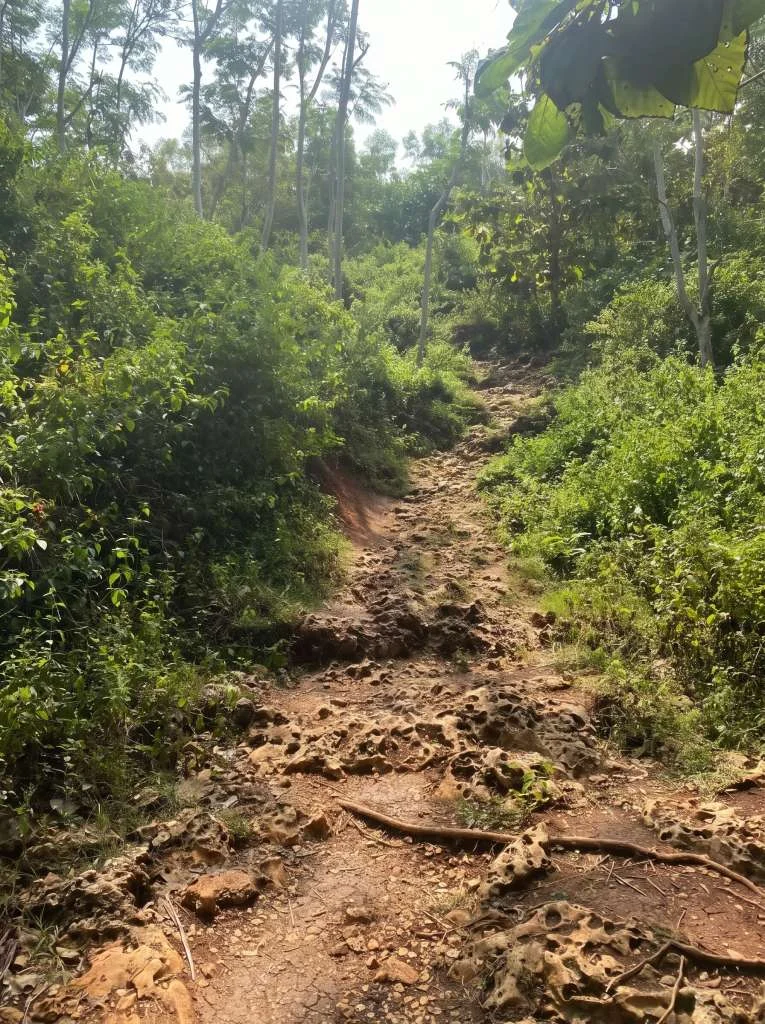
From this outpost, the terrestrial trek commenced on foot. Heavy afternoon rains earlier that day had transformed the narrow limestone trail into a treacherous path of thick mud and razor-sharp karst outcrops. Under the intermittent glow of a moon obscured by dense cloud cover and guided solely by handheld flashlights, the explorers navigated the downward slope toward the coastline. The iconic roar of the Indian Ocean—initially muffled by the dense topography of the karst hills—grew progressively louder, finally signaling proximity to the shore after an arduous descent in absolute darkness.
Environmental Hazards and Coastal Resilience
Arriving at the shore near midnight, the expedition members faced immediate environmental challenges characteristic of Java’s southern marine border. Tents were pitched directly onto the white-sand shoreline, oriented toward the open ocean and the crashing surf. However, the coastal microclimate quickly proved volatile.

As the night deepened, severe offshore winds and towering swells amplified, creating an acoustic and physical assault on the makeshift camp. Meteorological conditions deteriorated further when heavy squalls swept across the cove, testing the structural integrity of the camping equipment. The high-velocity winds exerted immense pressure on the tents, whose stakes struggled to achieve stable anchorage in the loose coastal sand compared to dense terrestrial soil. Ultimately, the severe weather forced the campers to dismantle and relocate one of their collapsing shelters mid-storm, executing emergency repositioning amid driving rain and howling gales.
This meteorological event underscores the inherent risks associated with unregulated coastal camping along the southern Java coastline. Local disaster management agencies and tourism boards in Gunungkidul consistently issue advisories regarding sudden tidal surges, rogue waves, and high-velocity wind storms—known locally as angin kencang—which frequently impact the exposed marine zones facing the Indian Ocean.
Dawn, Ecosystem Dynamics, and Post-Storm Analysis
With the arrival of morning, atmospheric conditions stabilized, replacing the nocturnal tempest with the coastal serenity characteristic of the region. Golden-orange sunlight broke across the eastern limestone ridges, casting sharp gradients of light and shadow over the white-sand cove and illuminating the sheer vertical drop of the surrounding karst cliffs.
Daylight revealed the true structural layout of Wohkudu Beach. The strand is notably compact compared to neighboring coastal destinations in Gunungkidul, yet its ecological composition is distinct. The dual limestone headlands serve as a vital natural buffer, absorbing the primary kinetic energy of oceanic waves and creating a localized ecosystem where visitors can temporarily access the shoreline safely.
The morning hours permitted a detailed inspection of the trail traversed the previous night. In full daylight, the descent path revealed itself as a steep, highly weathered geological track composed of sharp lapies (grooved limestone surfaces) and slippery clay-rich mud, emphasizing the physical hazards faced during the midnight hike.

Broader Implications and Regional Tourism Impact
The journey to Wohkudu Beach highlights a broader dichotomy within Yogyakarta’s regional tourism development: the tension between accessibility and environmental preservation. Gunungkidul has evolved from an isolated, economically depressed limestone plateau into one of Java’s premier nature-based tourism hubs. The development of the Daendels Southern Cross Road (Jalur Jalan Lintas Selatan or JJLS) has dramatically improved connectivity across the regency, transforming previously inaccessible hamlets into thriving economic zones.
However, remote sites like Wohkudu remain intentionally detached from mass-market tourism infrastructure. The absence of cellular signal, grid electricity, and vehicular access roads preserves the ecological integrity of the pocket beach, protecting fragile coastal flora and preventing the environmental degradation often associated with over-tourism. At the same time, this lack of infrastructure places a higher onus on individual preparedness, emphasizing the need for responsible outdoor ethics, comprehensive risk assessment, and adherence to safety guidelines when exploring dynamic geological zones.
Ultimately, expeditions into landscapes shaped by millions of years of tectonic activity offer more than recreational respite. They provide direct engagement with earth sciences, connecting modern travelers to the same primordial forces documented by naturalists nearly two centuries ago. Through the lens of geomorphology, meteorology, and personal endurance, the remote coast of Gunungkidul remains a living archive of Java’s dynamic natural history.