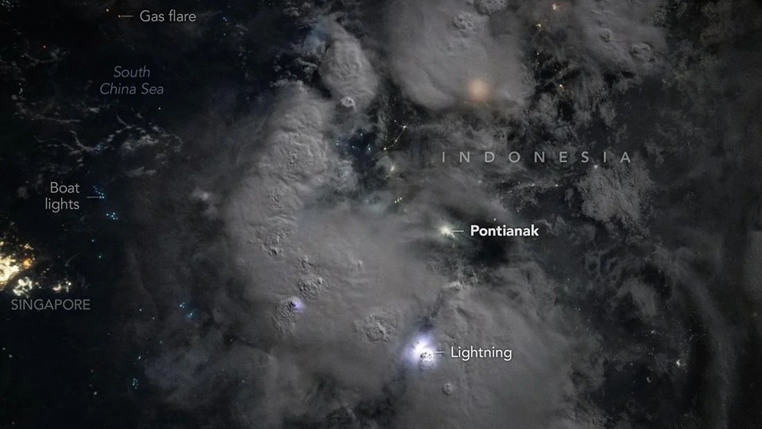
A breathtaking celestial perspective of a violent lightning storm over the South China Sea, in close proximity to the Indonesian island of Kalimantan, has been documented by astronauts aboard the International Space Station (ISS). Released by NASA’s Earth Observatory on November 17, 2026, the high-resolution imagery captures a sprawling atmospheric disturbance that resembles a cosmic firework display when viewed from low-Earth orbit. The photograph, secured on October 28, 2026, at 9:20 p.m. Western Indonesian Time (WIB), serves as a poignant reminder of the sheer scale of meteorological events occurring on our planet and the unique vantage point afforded to those stationed 400 kilometers above the surface.
A Chronology of the Observation
The capture of this image was not merely a stroke of luck but the result of the rigorous Earth observation programs conducted by the ISS crew. At the time of the exposure, the station was orbiting over the South China Sea, a region frequently characterized by intense convective activity due to its tropical climate and warm sea surface temperatures. The image was recorded using a Nikon Z9 digital camera equipped with a 14-millimeter lens, a setup specifically utilized by the ISS Crew Earth Observations facility to document the planet’s dynamic atmosphere.
Within the imagery, the lightning activity is not limited to the cloud layer. Because the ISS travels at approximately 17,500 miles per hour, astronauts are uniquely positioned to view the tops of storms rather than the bases. This allows for a clear observation of the "overshooting tops"—dome-shaped protrusions that signify the most intense parts of a storm. These formations occur when powerful updrafts within a storm cell possess enough kinetic energy to breach the tropopause, pushing moisture and ice crystals into the lower levels of the stratosphere. The presence of these tops serves as a reliable meteorological indicator for severe weather, signifying high-velocity vertical wind speeds and substantial precipitation potential.
The Astronaut’s Perspective: A Legacy of Observation
The visual sensation of lightning from space has long been a subject of fascination among spacefarers. NASA officials noted that the phenomenon observed near Borneo bears a striking resemblance to the descriptions provided by the late Sally Ride, the first American woman in space. In her essays for Air & Space magazine, Ride articulated the experience of witnessing orbital storms: “When the storm stretches for hundreds of miles, it looks like an intercontinental army tossing fireworks from cloud to cloud.”
Unlike observers on the ground, who experience lightning as a sharp, sudden flash filtered through the density of rain and cloud cover, astronauts see the light diffused through the top of the cloud structure. This creates a softened, glowing effect, where the massive cloud banks act as a lantern, illuminating the surrounding darkness of the planet. This contrast between the ethereal light of the storm and the stark blackness of the night sky provides a sensory experience that is entirely unavailable to those operating on the surface of the Earth.
Human Footprints in the Night
While the lightning is the primary subject of the photograph, the image is equally significant for its depiction of human civilization. The composition captures the intricate layout of Southeast Asia at night, with the urban sprawl of Singapore standing out in stark contrast to the surrounding sea. The Singapore Strait, a vital artery of global maritime commerce, is clearly defined, separating the city-state from the Indonesian islands of Batam and Bintan.
Further analysis of the image reveals a sophisticated map of human economic activity:
- Maritime Industry: Distinct clusters of blue light in the western reaches of the sea are attributed to fishing fleets. These vessels utilize high-intensity lamps to attract squid and schooling fish, such as sardines and anchovies, to the surface.
- Industrial Activity: Scattered orange points located in the northwest offshore regions are indicative of gas flaring—a common industrial byproduct of oil and gas extraction operations.
- Urban Infrastructure: The dense, stable concentrations of white and yellow light represent the established grid of major metropolitan centers, highlighting the disparity between the concentrated power consumption of cities and the dispersed activity of the maritime sector.
Scientific Context: The Scale of Global Lightning
The storm captured near Borneo is a microcosm of a much larger, relentless global process. According to NASA’s Earth Science and Remote Sensing unit at the Johnson Space Center, there are approximately 2,000 lightning-producing storms occurring at any given moment across the globe. These storms collectively generate nearly 60 flashes of lightning every second, totaling roughly five million flashes per day.
This data is vital for atmospheric scientists who monitor the "Global Electric Circuit." By tracking lightning frequency and location from space, researchers can better understand the thermal energy distribution of the atmosphere. The "overshooting tops" identified in the Borneo image, for instance, are critical data points for climatologists studying how extreme weather events might be intensifying due to shifts in global temperatures. The ability to document these events in real-time from the ISS provides a level of temporal resolution that geostationary satellites often struggle to match in terms of detail and color fidelity.
Implications for Research and Documentation
The integration of astronaut-led photography into Earth science research is more than an exercise in aesthetic appreciation; it is a fundamental tool for planetary monitoring. The ISS Crew Earth Observations program acts as a bridge between high-altitude satellite data and ground-based meteorological stations. Because astronauts can adjust their cameras and react to ephemeral events in real-time, they provide a flexible, "human-in-the-loop" approach to Earth observation that automated systems cannot replicate.
The documentation of this specific event over the South China Sea contributes to a long-term archive of human impact on the planet’s night-side. By comparing these images over decades, scientists can track urban growth, the expansion of industrial corridors, and shifts in shipping lanes. Furthermore, the photography serves a dual purpose: it functions as a primary source of data for researchers and as a powerful educational tool for the general public, fostering a broader appreciation for the complexities of Earth’s atmosphere.
Looking Forward
As the ISS continues its mission, the collection of such imagery remains a high priority. The data harvested from these observations informs studies on air quality, disaster response, and urban planning. The photograph of the Borneo storm, released as the "Image of the Day" on November 17, 2026, highlights the ongoing synthesis of advanced space technology and human ingenuity. It captures a moment where the chaotic beauty of nature meets the structured footprint of humanity, viewed through the lens of a station that orbits the globe every 90 minutes.
The resilience of these storm systems, coupled with the precision of the observation equipment, ensures that future missions will continue to provide insights into the planet’s volatile weather patterns. As NASA and its international partners continue to refine their imaging capabilities, the world can expect a clearer, more detailed understanding of the dynamic interactions between the atmosphere and the surface—a perspective that continues to change our fundamental relationship with our home planet. The lightning over Kalimantan is not merely a weather event; it is a testament to the persistent, electric nature of Earth, captured by those who have been granted the privilege of watching over it from the silent, orbital theater of space.